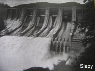
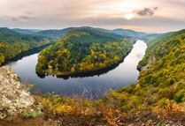
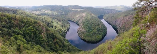
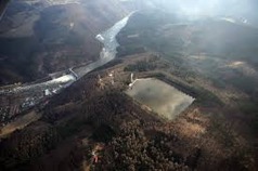
The Slapy dam is the sixth largest dam in the Czech Republic. It was built between 1949-1955. A 44-kilometer-long water work was created to regulate the Vltava River and to generate electricity. The original flow of the Vltava bore its way through granite rocks, the river was meandering and creating deep rocky valleys. The area around Slapy was not very fertile, so the Vltava was almost the only source of livelihood. Most of the people in the not-so-densely populated region made their living by rafting. Everything changed in the 1930s with the development of tourism and tramping.
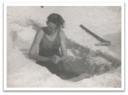
1 Ždáň – one of the most interesting inhabitants of Ždáň was Helena Fedievová, born 1906, called Vltavěnka. The old river and its meanders charmed her so much that she left a comfortable life in Prague and moved to a small cottage, which she built just by the river. In her childhood and youth, she suffered from many illnesses, including TBC, she began to treat them with a bath in Vltava. She bathed every day and in any weather, even when in winter it was 30 degrees below zero and she had to cut a hole in the ice. Gradually all the diseases disappeared. When her cottage had to retreat to the dam, local people built a new cottage in the bay near Ždáň. However, the place became too busy due to tourists and lost its romance. Helena died at the age of 80.
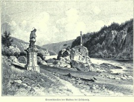
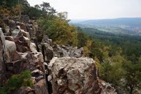
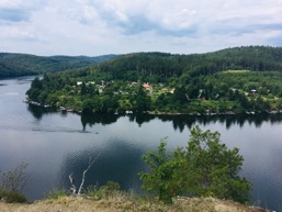
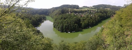
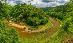
2 Svatojánské proudy (St. John’s Streams) – was a stretch of Vltava where the river flowed through a deep rocky valley and formed rapids. Most of the streams were flooded by Štěchovice dam, the rest later by Slapy dam. Rocks in the river were a dreaded obstacle for raftsmen. Some of the rocks were blasted in the 17th century and Ferdinand’s Column was erected on a rocky promontory according to the Emperor who ordered the blast. A statue of John of Nepomuk stood next to it and hence the name St. John’s Streams. In 1886, the Czech Tourists Club marked the first tourist route here. The area has become a favorite of tourists and hikers and there were camps such as Lost Hope.
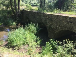
3 Construction of the dam – the construction of the dam was already decided during the World War II. The narrow site of the St. John’s Streams was chosen for the dam. As a result, the power plant had to be unusually placed directly in the dam below spillways. First, a bypass tunnel had to be built to allow the river to flow outside the dam construction so that it could be built dry. Three long cableways from surrounding villages, for example from Luka pod Medníkem, were built to supply the building with cement, sand and stones. Selected monuments, such as chapels, crosses and others, were moved above the surface of the lake before being flooded. The reservoir was filled quickly and atypically. In 1954 the still not fully finished dam began to fill, but a great flood came. Fortunately, the reservoir was not full and helped to retain water and save Prague from the devastating flood. The dam itself is 70 m high.
4 average water temperature of the Slapy dam
| Depth Level | |||||||
| Top | 5 m | 10 m | 15 m | 20 m | 30 m | Bottom | |
| Srpen | 19,7 | 18,0 | 16,0 | 15,9 | 14,7 | 13,8 | 11,5 |
| Září | 17,6 | 17,0 | 16,3 | 15,6 | 15,3 | 14,8 | 12,5 |
| Average per year | 11,9 | 10,5 | 9,5 | 9,2 | 8,9 | 8,6 | 7,9 |
5 Raftmen – the word “slap” was used by raftmen to denote a large stone in a river. They called the water that rolled over the stone a “slapnice”. Hence the name Slapy. The rafters sailed wood from the Šumava mountains. The cruise lasted from 4 days to a week. Back from Prague to Šumava they walked or rode bicycles. The raftsmen had to pass many knowledge examinations in order to be allowed to navigate and be able to sail through heavy stretches such as St. John’s Streams. The end of raftsmen came only with the advent of the railway but above all with the construction of the Vltava Cascade.
6 Centre
7 Kocába – Kocába and its immediate surroundings have been known for centuries for gold. So called Štěchovice gold-bearing district is situated between Nový Knín, Štěchovice and Davle and the mining took place in several historical stages, while there are considerations that the Celts could already pan for gold. In June 2003 the World Cup in Gold Panning was held in Kocába.
8 Brdy U Šraňků – “brdo” means a wooded hill. The highest peak of the Brdy Hills is Tok (865 m). The tower of the Czech Hydrometeorology Institute meteoradar is situated 862 m above sea level and it is the highest artificial peak of Brdy. In the Brdy area there was a military area. It was founded in 1926 (5 villages completely disappeared as a result of its establishment) and it was abolished in 2015. However, even after its abolition, some parts of the military area are used by the military, such as the secret building “At the Dumbs”. Because of the strict secrecy of the employees of the building, about whom no one knows what they are doing in the building, they are called “dumb”. The very small piece of the Brdy space remains closed due to the possible occurrence of unexploded ammunition.
9 Hýskov – the beginnig of the water section
10 Quarry Alkazar – on the plain above the quarry, there was a prehistoric fortified settlement Hostim. Mining of limestone in the quarry took place mainly in the first half of the 20th century, as well as in the quarries Amerika, which are nearby. During the World War II, the Germans wanted to turn the quarry into a factory for the production of V-1 and V-2 rockets. But the idea was dropped in the end. From that time comes the legend of the spirit of the SS member Hagen, who wanders in adits. Radioactive waste was deposited in adits in the 1950s. Bats reside in tunnels and some adits and caves are valuable due to karst phenomena.
11 End of the water section
12 Crossroads of hiking paths
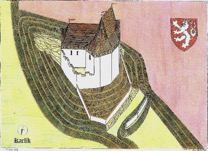
13 Karlík Castle – we don’t have much information about the Karlík Castle. According to a legend and chronicles it was built by Charles IV. for the Empress and her retinue, because the women were not allowed to enter Karlštejn. But in fact, women could go to Karlštejn, except for the Great Tower, which was a sacred place. The Karlík castle was probably founded to protect Karlštejn. However, it was never finished, perhaps it was conquered in 1422 and has been abandoned since then.
14 Karlštejn – Karlštejn Castle was founded in 1348 by Emperor Charles IV., first as a private representative place. After the imperial coronation in 1355, the purpose of the castle was changed. It became a treasury for the imperial coronation jewels and a set of holy remains, which Charles IV. gathered. If Charles IV lived. in our century, he would probably be a great athlete, maybe he would try CZAR as well. At that time he was tall (173 cm) and was very physically fit. He liked to seek out adrenaline and incognito, under a foreign name and coat of arms, participated in knightly tournaments. However, at a tournament in Italy in 1350, he met a stronger rival. After the stroke of a handstave, Karel fell from his horse and bruised his cervical spine and broke his lower jaw for several times. Italian healers then found in horror that he was paralyzed. Karel underwent a difficult and unique operation under leadership of Italian doctors. First, they straightened his spine with a strong pull. Then they sutured his wounds in the mouth and kneaded with gold wire on the broken lower jaw. The doctors were soothing the terrible pain with a sleeping sponge dipped in a solution of opium, mandrake and hemlock. After 10 days, Karel was out of danger and was secretly transported to Bohemia to the Bezděz Castle. In order to preserve the king’s honor and to conceal his tournament and wounds, the rumor of his poisoning was spread. After some time Charles IV recovered, rehabilitated by horseback riding and practiced broken fine motorics by carving from wood. To cover the scars on his face, he had a beard grow. But his back was forever crooked, and for the rest of his life he was in pain.
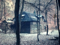
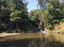
15 Bubovické waterfalls and Kubrychtova shed – several limestone stages form a small water cascade through which the Bubovický brook flows. Most of the waters have waterfalls during spring thaw or autumn rains. Due to the drought lasting several years, it is likely that the waterfall will be found dry. In winter, it sometimes freezes and forms a small icefall. The nearby Kubrychtova Shed was built around 1921 by Anna and Josef Kubrycht, who decided to build a log cabin with a small pub and accommodation. Before the war, more wealthy tourists and then the local cream of society used to come here, especially for the renowned hunting feast. In the 1950s, the site was discovered by tramps. Josef Kubrychta died and his wife Anna was left alone. She was nicknamed Bábinka from the tramps. She didn’t trust them at first. Sometimes 50 people slept in the shed. Electricity has never been introduced into the shed (and still is not), which added to its romanticism. Bábinka died in 1983. Conservationists prevented the pub from being reopened and appropriated the shed. Then the hut mysteriously burned down and a new one was built. It is used by nature conservationists and sometimes by scouts.
16 Svatý Jan pod Skalou – cross, lookout tower – from the lookout tower you can see the baroque building of the church of St. John the Baptist, that hides a karst hermit cave. In 880, the first Christian hermit, Ivan, settled there, according to the legend, the domesticated deer was his only companion. According to skeletal remains, he lived in dampness and fed on plant food. The hermit was said to have been visited by St. John the Baptist several times, who saved him from the devil and temptation. The underground spaces of the church have a total of three parts and you will see an underground spring of mineral healing water, a bed and a boulder with footprints of a hermit Ivan, and a ceiling opening through which Ivan drove evil spirits from the cave.
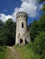
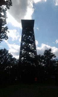
17 Lhotka lookout tower near Beroun – Combined telecommunication tower of T-Mobile with lookout platform. It is 45 m high and the viewing platform is 25 m above the ground.
18 Hýskov village – In the area of Hýskov there were vessels with ash from older Bronze Age found. Later the Celts lived here. The first written record dates from 1088. In the Middle Ages, the so-called Royal Route from Karlštejn Castle to Křivoklát led through the village.
19 Lookout tower Děd – Lookout tower on the hill Děd (493 m) is 12 m high and has the form of a castle tower. In 1893 it was built by the Beroun department of the Czech Tourists Club as the first lookout tower in the Czech lands. Thanks to the tall trees you won’t see much of it, but it still has its charm.
20 Axamit Gate and Jelínek Bridge – Axamit Gate is the largest rock bridge in the Bohemian Karst and was created by the collapse of the ceiling of a large cave, which left the connecting gap in the east. The preserved formation formed the mouth of this cave. The formation was named after the physician and archaeologist Jan Axamit. Jelínek Bridge is also a rock formation formed by a narrow, deep gorge, whose approximately 1 m distant edges are approached in two places so that they touch and form an interesting karst phenomenon resembling an elevated Gothic broken arch. Both “holes” in the limestone rocks are situated on the western promontory of the Golden Horse Hill, inside of which there are Koněprusy Caves (the word koně means horses, the word prusý means white in Old Czech, then White Horse Caves). The promontory above Suchomastský Brook is part of the nature reserve Kotýz. It was named after the Thracian goddess Kotys, whose cult was brought here by the Celts. They allegedly kept sacred white horses, one of them was later sent by queen Libuše to king Přemysl with a message. Even the legendary horse named Šemík was supposed to come from here, the chronicler Hájek of Libočany said.

21 Plešivec Lookout – On the top of Plešivec (654 m), there was a fortified settlement from the Late Bronze Age. It was one of the largest in Bohemia. On the top there were foundries of bronze, which probably processed copper and tin from the Ore Mountains. Metal processing is evidenced by the discovery of foundry furnaces, which found, among other things, a bronze alloy weighing 17 kilograms with traces of partially melted tools. At the same time, a small group of founders lived here, documented by the ceramics of Knoviz culture. It is assumed that only metalworking specialists lived in the area, and residents of the surrounding countryside were banned.
22 Studeny vrch (Cold hill) Lookout – A 17.5 m high hexagonal tower was built in 1940 on the top of Cold Hill, which was named after the cold wind still blowing. It first served for surveying purposes. The tower leads 81 and although not too high, it has a nice view, sometimes the Krusne Mountains.

23 Rochota – Orienteering – Former gamekeeper’s lodge. The word rochoty means a scree, a rocky place or small rock gardens and was created according to the sound form – the collapsing stones cause a rumble, a rattle. Such places began to be called Rochoty (origin is Old Slavic, places of that name occur from Ukraine through the Balkans, Czech Republic and Poland and always refer to similar-looking places). Today the gamekeeper’s lodge is demolished and a new pension with guest house and restaurant is replaced.
24 Arbor – Arbor is located in the middle of the former game preserve King’s Stool, founded in the middle of the 18th century by the Dobříš Lord Jindřich František Mansfeld and was one of the largest in Bohemia. Red deer (deer, fallow deer) was bred here. The gazebo was originally from birch trunks. Today it is restored in a different form. Around there was a circular intersection and six more radial intersections from the gazebo to the edge of the game park

25 Malá Lečice – waterfall, where scenes from the Czech romantic movie “Summer with a cowboy” was filmed.
26 Centre
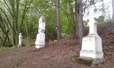
27 – The Three Crosses, the center of the Kingdom of Bohemia – in fact, there is no center of any territorial unit. The place where the three crosses are located is surrounded by many legends. It is not known exactly who and when had the crosses built. Perhaps it was Jakub Záhorský, a retired soldier and native of the village Záhoří. But why he had them built is kind of a mystery.
28 Šemík’s Leap – The lookout is named after the mythical horse Šemík, who saved life of his master Prince Horymír. Šemík jumped from the Vyšehrad Castle in Prague to the Vltava River and took his master to the village Neumětely. After that, he succumbed to his injuries. Legend is probably based on Germanic sagas.

29 Abbot’s Viewpoint – Methodius Jan Zavoral (1862–1942) was the abbot of the Strahov Monastery in Prague and a senator. He organized the funeral of his friend, famous czech writer Karel Čapek, who, after the Munich Agreement, found himself unpleasant to the public. He was a co-founder and chairman of the Czechoslovak-Romanian Society and supported various charitable associations and institutes.
30 Written rocks lookout (Psané skály) – Religious inscriptions are engraved on the lookout. It was founded in the 16th or 17th century and its authors are members of some branch of the Czech brothers who hid here from being persecuted by Catholics.
31 Cove Slapyy
32 Centre
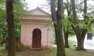
33 Chapel Rovinek – small empire chapel founded in 1841 by Jan Záhorský. The chapel originally towered 50 m above the water before the Slapy dam flooded. St. John’s Streams started just below it. Below the Rovinek there was a restaurant and hotel Záhoří, which was the starting point for many hikers. In 1935, Rudolf Formis was murdered by Gestapo at the hotel. He had an illegal radio in one of the rooms and regularly broadcasted to Nazi Germany. Today the hotel is at the bottom of the dam.
34 Camp Ztracenka (The Lost Hope) – in 1918, after the World War I, young boys returned to civilian life. Some of them tried to forget their experiences of war in nature. Every Saturday they walked to St. John’s Streams from Prague. The romantic and wild gorge provided an ideal place for camping. The name Lost Hope was given to the camp after the gold-mining camp from the American western Red Ace. The first hut, if it could be called a shelter of branches, twigs and pieces of cardboard, was built in a former quarry under “Ant Rock” and it was called “Kadič”. In 1922 the camp had 105 male and 18 female members. There was a lot of sports in the camp, and it was especially famous for volleyball tournaments. In 1929 and 1941 the camp survived two major spring floods, which almost destroyed it. The worst thing was the flooding of Štěchovice and Slapy dams, when Ztracenka had to move to the place where it still stands.

35 Štěchovice – Závist
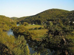
36 Medník peak – (416 m) is often mentioned in songs by Czech tramps.
37 Kliment Lookout – The lookout was named after Josef Kliment (1858–1938), a teacher, a longtime member of the Czech Tourism Club and the author of tourist guides.
38 Smetana’s Viewpoint – named after the Czech composer Bedřich Smetana (1824–1884). The second symphonic poem from the cycle My Homeland conceived Smetana as a description of the flow of the Vltava from the springs, through the flow of forests and the landscape where the wedding is celebrated, then the night landscape where the water nymphs dance, around castles, chateaux and ruins to Prague and finally to confluence with the Labe River. One part is devoted directly to St. John’s Streams.
39 May Lookout – one of the most beautiful views of the Vltava River
40 Lookout Bednář – less known and visited lookout, but as beautiful as the May lookout
41 Jirka’s sister – the sister of one of the organizers lives here
42 Centre
43 Drtina’s Lookout Tower – – In honor of a significant native prof. PhDr. František Drtina from nearby Hněvšín was inaugurated on 11 July 1926 a new wooden lookout tower on the Besedná hill (496 m), which is located near Živohošť. The tower was 22 m high, in the shape of a Hussite watchtower. It was built by local tourist enthusiasts at Besedná, where František Drtina liked walking and where his friends such as writers Alois Jirásek and Julius Zeyer and musician Josef Suk were inspired. The first Czechoslovak president T.G. Masaryk contributed to the construction of the tower.
44 Bridge – a nature trail dedicated to famous writer Karel Čapek leads across the bridge. He was given a gift of a small villa at the Strž pond as a wedding gift. The place became fatal to him. In 1938, immediately after the great flood that affected the villa and its surroundings, he began to liquidate the damage. He had a cold, and in December, due to his overall poor health and psyche, he died of pneumonia. But death saved him from being deported to a concentration camp that his brother Josef Capek had not escaped. The Villa currently houses the Karel Čapek Memorial.
45 Quarries near Nečín – Bolskros – this special discipline originated as a pastime for students at sports courses of the University of Economics. The design and construction was mostly taken by one of the teachers of the Department of Physical Education and Sport – Miroslav Bolf. But because of his nickname “Bols”, came the name: Bolskros. You are lucky, this year’s cross was prepared for you by this living legend.
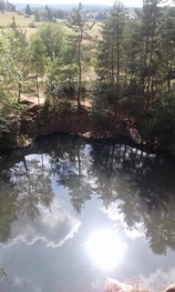
46 Hříměždice Pier – The granite quarry was flooded by accident when the miners encountered a strong lower spring. The maximum depth is 8 m and was therefore used as a training center for military divers. Today the quarry is used for swimming, jumps into the water from a height of 1-10 m and weaker nature can sunbath on the pier.
47 Veselý vrch Lookout Tower – (Cheerful hill) – The Veselý Hill Lookout Tower near Mokrsko (489 m) is a 42-meter-high steel tower. It is interesting that at the opening of the world champion in cycling Josef Dressler jumped the stairs of the lookout on a bike. With perfect visibility, you can also see alpine peaks, as well as the Krkonoše Mountains or Kleť, a mountain in the Šumava mountains in South Bohemia.
48 Corner Meadows
49 The Štěchovice pumped-storage power plant was built partly at the same time as the Štěchovice Dam in 1941–1947. While the power plant is located in the dam area at the bottom of the river valley, the storage reservoir is situated at the top of the adjacent Homole Hill. Both buildings are connected by a high-pressure steel pipe with a diameter of almost 2 meters and a length of 590 meters, resulting in a gradient of up to 220 meters. The pool at the top has a volume of 500,000 m². During its construction, the whole top of the hill was removed and the reservoir was completed within a few years using heavy machinery.
50 Chapel Rovinek – see 33
51 Centre and the end of race